Dholera SIR Map Explained — Zones, TP Schemes, and What Each Area Is Planned For
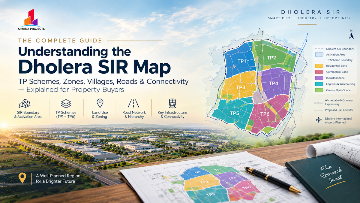
If you've looked at a map of Dholera SIR and felt a bit lost — a big outlined area, some numbered zones, a scattering of village names — you're not alone. It looks complicated because it genuinely is a fairly large, structured region, not because you're missing something obvious. This is a walkthrough of how the region is actually organized, so the next map you look at makes a lot more sense.
Start With The Big Picture
Dholera Special Investment Region covers roughly 920 square kilometers, which is a genuinely large planning area — bigger than a lot of existing Indian cities. Because of that size, it isn't developed as one uniform block. It's broken down into a smaller "activation area" — the initial zone where infrastructure and development are being prioritized first — plus the wider SIR boundary that will be developed over a longer timeframe as the region grows.
Most of what's actually being built and sold right now sits within or near that activation area, which is worth knowing because it explains why some parts of the region show real infrastructure progress while other parts, technically still "within Dholera SIR," are much earlier in their planning journey.
What a Town Planning (TP) scheme Actually is

This is the part that trips people up the most, so it's worth explaining clearly. Within Dholera SIR, land isn't just divided into random plots — it's organized into numbered Town Planning schemes, each covering a defined area and often incorporating one or more existing villages. You'll see references like TP-1, TP-2, TP-4, and further sub-divisions like TP 4/B2.
Each TP scheme goes through a process called reconstitution, where the original land parcels (a lot of which started as agricultural holdings owned by local farmers) get consolidated and redistributed into a planned layout — with roads, defined plot boundaries, and zoning already worked out. Once that process is complete for a given scheme, individual plots within it get assigned a Final Plot (F.P.) number, which is the actual legal reference used for that piece of land going forward.
This matters a lot for anyone reading a Dholera SIR map, because different TP schemes are at different stages of this process. Some are fully reconstituted with demarcated, ready-to-register plots. Others are still earlier in the pipeline. The map alone won't tell you that — you have to ask about the specific scheme.
The zones you'll typically see marked on a Dholera SIR map
Beyond the TP scheme numbers, maps of the region usually highlight a few broad zone types:
Residential zones, set aside primarily for housing development — these make up a large share of the region's planned land use, since Dholera is meant to eventually house a significant population.
Industrial zones, positioned to take advantage of the region's logistics access and infrastructure — this is where you'll find land earmarked for manufacturing, including the areas associated with the semiconductor and electronics investment the region has been attracting.
Commercial and mixed-use zones, often positioned along wider roads and near residential clusters, meant to support retail, offices, and the kind of shop-cum-office development that serves a growing population.
Logistics and warehousing zones, generally positioned with good road and eventually rail/air access in mind, given the region's ambitions as an industrial and export hub.
A "central business district" style zone in some planning documents, envisioned as a denser commercial core once the region matures.
Not every map you come across will label all of these the same way, and specific zone boundaries can be refined over time as DSIRDA's planning evolves — but this is the general logic behind how the region is laid out.
Villages inside Dholera SIR
Because the SIR boundary was drawn around a cluster of existing villages rather than genuinely empty land, you'll often see village names — Bhangadh, Kadipur, and others — referenced alongside TP scheme numbers on maps and in listings. These villages sit within specific TP schemes, and that combination (village name plus TP scheme number) is usually how a specific area within Dholera SIR gets identified in practice.
If you're looking at land in, say, Bhangadh, what you're really looking at is land within whichever TP scheme covers that village — and the same due diligence about reconstitution status and zoning applies regardless of which village name is attached to the listing.
Roads And Connectivity Shown On The Map
A Dholera SIR map will usually also show the region's planned road hierarchy — arterial roads (the widest, main connecting roads, often 48m to 70m wide), sector roads, and internal roads within individual TP schemes. This matters for evaluating any specific plot, since frontage on a wider arterial road generally carries more value and better long-term usability than a plot on a narrow internal lane, even within the same TP scheme.
Increasingly, maps also show the region's bigger infrastructure connections — the alignment of the Ahmedabad-Dholera Expressway, the location of Dholera International Airport, and more recently, the planned route of the Ahmedabad-Dholera semi-high-speed rail corridor that got Cabinet approval earlier in 2026. These external connections matter alongside the internal TP scheme structure, since a plot's value is shaped by both where it sits within the region and how well the region overall connects outward.
Rather than just looking at a map for a general sense of the region, use it to ask specific questions: which TP scheme does a given plot fall into, and how far along is that scheme's reconstitution process? What's the road width bordering the actual plot, not just the general area? How far is it from the activation area boundary, the expressway alignment, or the airport corridor? A map is a starting point for these questions, not a substitute for getting specific answers about the individual plot.